Web Tools
Scenario App Offshore Windparks
Szenario App Offshore Windparks
AIS Data Analysis
The R package extracts, interpolates and corrects ship positions and speeds from AIS data
© Rémi Pigeault
We developed an open access R-package to analyze, correct, interpolate and extract AIS data for desired locations and times. Few products and information are available to date on appropriated practices to analyze AIS data, and more importantly, few tools were developped. This limits the studies including vessel presence, speed and vessel noise. This product comes to fill this gap. GitHub Link
| Infobox AISanalyze | |
|---|---|
| Title: R-package to correct, extract and analyze AIS data Category: Application Project: CoastalFutures Audience: Policy and Administration, Science, End-users Partner: TiHo-ITAW Contact: Anita Gilles |
Fish Larvae Library
Fish Larvae Online Library
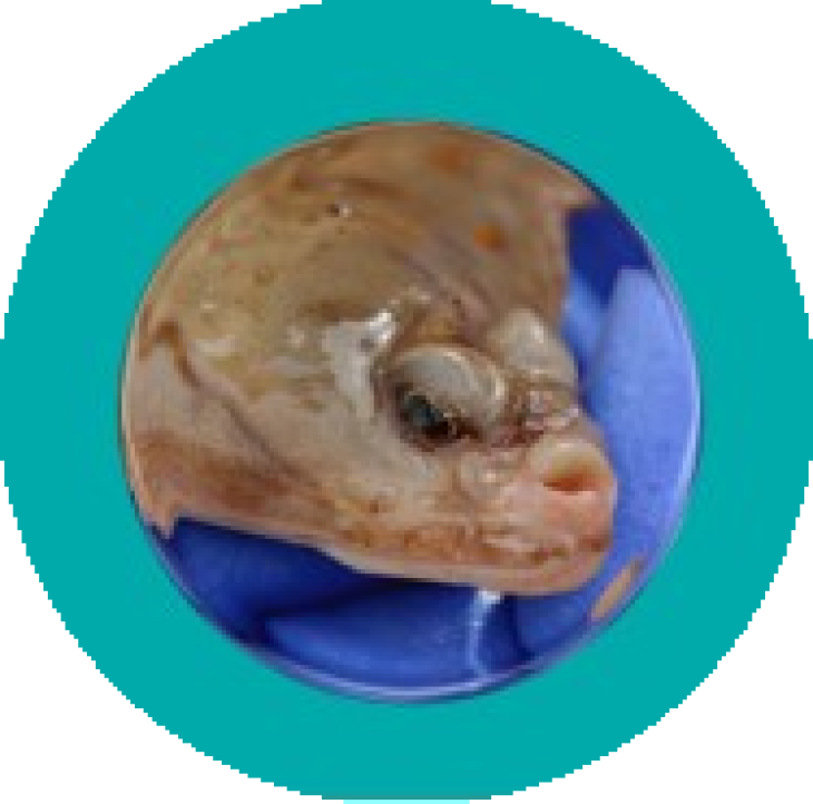
© Thünen-Institut / Christina Waitkus
Early-life history of marine fishes is one of the main drivers of the recruitment variability and an important bottleneck in the adaptation of fish populations to changing climate. Our online library represents a collection of physiological models of fish larvae designed to study starvation mortality, as one of the main sources of larval mortality in marine ecosystems. The library encompasses single-species models for various fish species and promote development of generic approaches for larval fish modelling. Additionally, the library compiles data from laboratory experiments and field studies used to parameterize, calibrate and validate those models. Our Online Library aims to provide a one-stop resource for researchers interested in larval IBMs as a powerful tool to investigate drivers of fish recruitment. By consolidating these models and data in one place, we hope to facilitate future research in this critical field and contribute to the sustainable management of fish populations" Fish Larvae Online Library Thünen-Institute
| Infobox Fish Larvae Library | |
|---|---|
| Title: Fish Larvae Online-Library Category: Applications Projects: CoastalFutures Audience: Science Partner: Thünen Institut für Seefischerei, Helmholtz Zentrum Hereon |
Marine Mammal Indicator
Assessment of Cetacean Abundance and Distribution
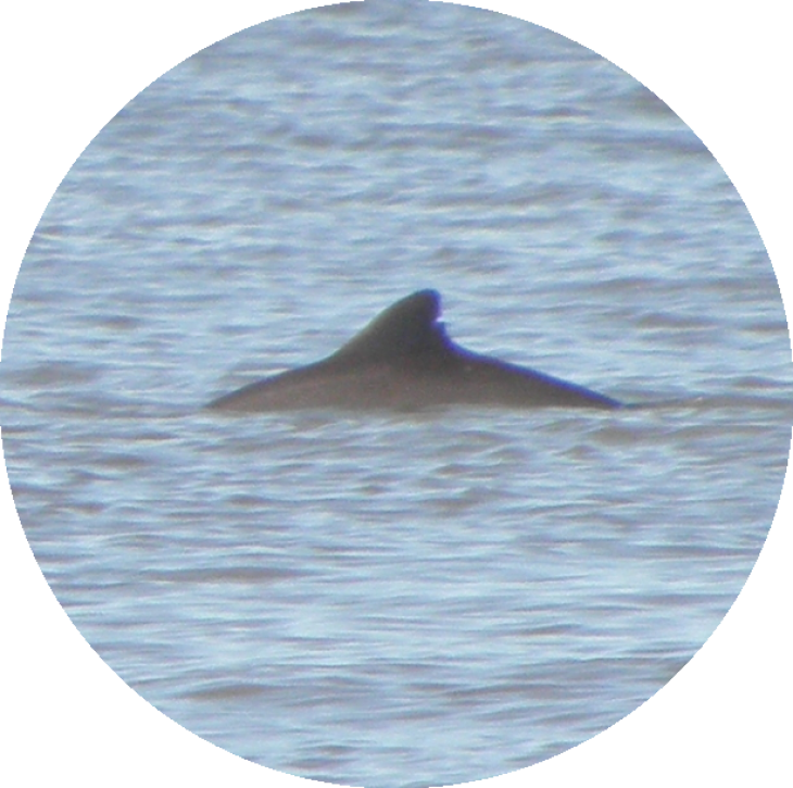
© K. Hoppe/ hereon
Marine mammals are an important component of marine biodiversity and key indicators of environmental status, such as food web integrity. As part of the OSPAR Quality Status Report 2023, an assessment of cetacean abundance and distribution was developed together with France and the Netherlands, with contributors from all OSPAR contracting parties. This assessment evaluated the status of 11 cetacean species/species groups. CoastalFutures has contributed by developing species distribution models that relate the density of species to features of their habitat to produce maps of predicted density distribution in the North-East Atlantic Ocean. As a result, the quantitative and qualitative assessments have revealed that many species and populations are not in good status. Moreover, limited improvement has been observed compared with previous assessments. Marine mammals are subject to significant pressure from both natural impacts and human activity. Many pressures still occur on a wide scale today, such as incidental by-catch in fisheries, or are even increasing, such as noise and hazardous substances, habitat loss or degradation of habitat.
The OSPAR Quality Status Report is produced every 10 years, with intermediate assessments every 5-7 years, and aims to assess the environmental status of the North-East Atlantic against the objectives of the North-East Atlantic Environmental Strategy 2010-2020 (NEAES 2020) and identify actions to achieve a clean, healthy and biologically diverse North-East Atlantic Ocean, which is productive, use sustainably and resilient to climate change and ocean acidification.
OSPAR assessment portal
| Infobox Marine Mammals Indicator | |
|---|---|
| Title: Assessment of Cetacean Abundance and Distribution Category: Marine Policy (MSFD Descriptor 1: biodiversity) Project: CoastalFutures Audience: EU Decision-Makers and authorities implementing the MSFD Partner: France, Netherlands |
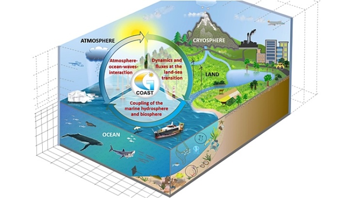
Coastal Modeling Framework (COAST)
Based on the coupled model system COAST (Coupled cOAstal model SysTem) developed at the Helmholtz Centre Hereon, new model instruments are being developed as part of Coastal Futures to better address specific questions regarding the protection and utilization of coastal regions. COAST is a model system that flexibly integrates the key components of regional and coastal modeling and additionally allows the incorporation of information from observations. Thus, it provides the ideal foundation to:
i) investigate physical processes in the atmosphere, ocean, and the role of waves at the atmosphere/ocean interface. In Coastal Futures, the atmospheric model COSMO-CLM, the ocean model NEMO, and the wave model WAM are dynamically coupled. The goal is to understand the interaction of components and their variability under changing environmental conditions at regional and interregional scales.
ii) better understand the impact of climate change and anthropogenic stressors, such as the influence of offshore wind energy and fisheries, on the coastal ecosystem. Therefore the model framework is expanded with more accurate models for various fish species. This includes coupling ECOSMO E2E with the multi-species model OSMOSE (Wolfshaar et al. 2021) and the implementation of Individual-Based Models for juvenile fish .
iii) examine the impact of climate change on the distribution of key species. For this purpose habitat models for fish, marine mammals and sea birds are integrated into the model framework.
iv) conduct simulations for the analysis of biogeochemical processes by coupling the ocean model NEMO with the biogeochemical model ECOSMO-E2E.
1. Model Configurations
1. Model Configurations
- 1.1 GCOAST - ESM Model Configuration
- 1.2 Coupled ocean atmosphere model IOW-ESM
- 1.2 Costal Finite-volume Sea Ice-Ocean Model – FESOM-C
GCOAST
Grafik: Ha Hagemann/ Hereon
The Helmholtz-Zentrum Hereon has developed the GCOAST (Geesthacht Coupled cOAstal model SysTem) coupled modelling framework, flexibly integrating the most important key components of regional and coastal modelling and, additionally, allowing to include information from observations. The main advantage of coupling is to allow coupled models to interactively exchange, during runtime, a variety of simulated fields that should otherwise be approximated. The GCOAST domain covers the North Atlantic Shelf region, the North and the Baltic Sea. For CoastalFutures, it is forced by downscaled global climate change scenarios data from the Coupled Model Intercomparison Project Phase 6 (CMIP6) suite for the last and the current century.
Physical processes taking place in the Atmosphere, Ocean and Waves are investigated through runs coupling the COSMO-CLM atmospheric model, the NEMO ocean model and the WAM wave model. In particular, the properties and the response of the three compartments on regional to transregional scales to the changing environmental conditions on climatological time scales will be analysed. Furthermore, for the Souhern North Sea, the local effects of specific anthropogenic changes (e.g. wind farms) on decades time scale are studied through coupled ocean-waves higher resolution runs. This allows to take into account physical interactions not captured by coarser resolution models. In addition, runs will be conducted that fully couple one of two atmospheric models, COSMO-CLM or ICON-CLM, the hydrologic discharge model HD, and the ocean model NEMO, which close the water balance in the regional Earth system.
For the analysis of biogeochemical processes, runs coupling the Ocean model NEMO and the biogeochemical model ECOSMO-E2E are carried out. ECOSMO-E2E is a functional group type model that resolves the major nutrient cycles in the system as well as lower and higher trophic production including fish and macrobenthos. The ecosystem model dynamics are coupled through the Framework for Aquatic Biogeochemical Models (FABM) to facilitate the coupling with NEMO.
Read further
| Infobox GCOAST | |
|---|---|
| Spatial coverage: North Atlantic Shelf region, North Sea, Baltic Sea Spatial resolution: ~12km (atmosphere), ~8km (hydrology), ~3.6km (ocean, waves, biogeochemistry), ~400m for ocean model over the Southern North Sea and English Channel Temporal coverage: 1961-2100 Temporal resolution: depending on the variables hourly, daily or monthly Contact: Sebastian Grayek, Marica Broseghini, Ha Thi Minh Ho-Hagemann, Stefan Hagemann, Deborah Benkort, Ute Daewel (Hereon) |
References
- Grayek, S., Wiese A. , Ho-Hagemann, H. T. M., Staneva, J., (2023): Added Value of Including Waves into Coupled Atmosphere-Ocean Model System within the North Sea Area, Frontiers in Marine Science, DOI 10.3389/fmars.2023.1104027
- Staneva, J., Grayek, S., Behrens, A., & Günther, H. (2021): GCOAST: Skill assessments of coupling wave and circulation models (NEMO-WAM). Journal of Physics: Conference Series, Vol. 1730, 01207I, doi:10.1088/1742-6596/1730/1/012071
- Ho-Hagemann, H.T.M., Hagemann, S., Grayek, S., Petrik, R., Rockel, B., Staneva, J., Feser, F., & Schrum, C. (2020): Internal Model Variability of the Regional Coupled System Model GCOAST-AHOI. Atmosphere 2020, 11, 227, doi:10.3390/atmos11030227
- Wiese, A., Staneva, J., Ho-Hagemann, H.T.M., Grayek, S., Koch, W., & Schrum, C. (2020): Internal Model Variability of Ensemble Simulations With a Regional Coupled Wave-Atmosphere Model GCOAST. Front. Mar. Sci. 7:596843, doi:10.3389/fmars.2020.596843
- Wiese, A., Stanev, E., Koch, W., Behrens, A., Geyer, B., & Staneva, J. (2019): The Impact of the Two-Way Coupling between Wind Wave and Atmospheric Models on the Lower Atmosphere over the North Sea. Atmosphere 2019, 10, 386, doi:10.3390/atmos10070386
- Daewel, U., Schrum, C., and Macdonald, J. I. (2019) Towards end-to-end (E2E) modelling in a consistent NPZD-F modelling framework (ECOSMO E2E_v1.0): application to the North Sea and Baltic Sea, Geosci. Model Dev., 12, 1765–1789, https://doi.org/10.5194/gmd-12-1765-2019
- Daewel, U. & Schrum, C. (2013) Simulating long-term dynamics of the coupled North Sea and Baltic Sea ecosystem with ECOSMO II: Model description and validation. Journal of Marine Systems 119–120, 30–49.
1.2 Coupled ocean atmosphere model IOW-ESM
Earth System Model of the the Leibniz Institut of the Baltic Research (IOW-ESM) produces climate change scenarios for the most common ocean and atmospheric variables. It downscales global climate change scenarios from the CMIP6 suite using a coupled ocean atmosphere general circulation model with a passively coupled marine biogeochemistry module. In CoastalFutures, this model is used to produce a climate change ensemble to assess future changes in air temperature, precipitation, water temperature and salinity, oxygen, productivity, water pH, sea level, and many other variables up to the year 2100. The regional climate projections will be used to produce scenarios for marine ecosystems using impact models (e.g species distribution models).
Read further:
https://www.io-warnemuende.de/coupled-model.html
| Infobox | ||
|---|---|---|
| Spatial resolution: 3nm Temporal coverage: 1961-2100 Temporal resolution: daily to monthly, hourly for the SSH Responsible Project Partner: IOW Contact: Matthias Gröger | ||
References
- Steger, C.; Bucchignani, E. Regional Climate Modelling with COSMO-CLM: History and Perspectives. Atmosphere 2020, 11, 1250. https://doi.org/10.3390/atmos11111250 More information about the reference
- Neumann, T., Koponen, S., Attila, J., Brockmann, C., Kallio, K., Kervinen, M., Mazeran, C., Müller, D., Philipson, P., Thulin, S., Väkevä, S., and Ylöstalo, P.: Optical model for the Baltic Sea with an explicit CDOM state variable: a case study with Model ERGOM (version 1.2), Geosci. Model Dev., 14, 5049–5062, 2021, https://doi.org/10.5194/gmd-14-5049-2021 More information about the reference
FESOM-C is the coastal branch of the global ocean model FESOM2 developed to address the small-scale dynamics in the coastal waters, which are not usually covered by the ocean models. Its high spatial and temporal resolution allows us to study formation, spreading, and mixing of the water masses on the shelf and how these affect the biogeochemical cycle of the shelf waters. It is particularly suitable to study tidal residual circulation on the shelf and its changes under the influence of climatic factors, as well as the impacts of sea level rise on terrestrial zones. In CoastalFutures, this model provides a base for analysis of the Sylt-Rømø Bight dynamics, from physical processes to the food web and ecosystem conditions.
Read further:
https://fesom.de/models/fesom-c/
| Infobox | |
|---|---|
| Spatial resolution: up to 2 m in the tidal wetting/drying zones Temporal coverage: 2010-2020 Temporal resolution: minutes to hours Responsible Project Partner: AWI Contact: Gaziza Konyssova, Vera Fofonova |
References
- Androsov, A., Fofonova, V., Kuznetsov, I., Danilov, S., Rakowsky, N., Harig, S., Brix, H., and Wiltshire, K. H.: FESOM-C v.2: coastal dynamics on hybrid unstructured meshes, Geosci. Model Dev., 12, 1009–1028, https://doi.org/10.5194/gmd-12-1009-2019, 2019. More information about the reference
- Kuznetsov, I.; Androsov, A.; Fofonova, V.; Danilov, S.; Rakowsky, N.; Harig, S.; Wiltshire, K.H. Evaluation and Application of Newly Designed Finite Volume Coastal Model FESOM-C, Effect of Variable Resolution in the Southeastern North Sea. Water 2020, 12, 1412. https://doi.org/10.3390/w12051412 More information about the reference
2. Hydrological System Components
2. Hydrological System Components
Global models provide us boundary conditions for the regional models and are important to produce climate projections.
2.1 Global Hydrological Model (HydroPy)
HydroPy model provides riverine input of fresh water and nitrogen into the ocean. This model represents a further development of the Max-Plank-Institute Hydrological Model (MPI-HM).
Read further:
https://zenodo.org/record/4730160#.YtkFS99CRPY
| Infobox | |
|---|---|
| Markdown Monster icon Spatial resolution: 0.5° Temporal coverage: from years to centuries Temporal resolution: daily Responsible Project Partner: HEREON Contact: Stefan Hagemann |
References
- Stacke, T. and Hagemann, S. (2021): HydroPy (v1.0): a new global hydrology model written in Python, Geosci. Model Dev., 14, 7795–7816, https://doi.org/10.5194/gmd-14-7795-2021 More information about the reference
- Stacke, T. and S. Hagemann (2012) Development and validation of a global dynamical wetlands extent scheme. Hydrol. Earth Syst. Sci. 16, doi:10.5194/hess-16-2915-2012: 2915-2933 More information about the reference
2.2 Hydrological Discharge Model (HD model)
HD model provides riverine input of water, consistent with the climate forcing. The model has been currently extended to include riverine transport of nitrogen and phosphorus In CoastalFutures, this model will be used to provides riverine input of water, nitrogen and phosphorus into the regional hydrodynamic and biogeochemical models.
Read further:
https://zenodo.org/record/5707587#.YtkFad9CRPY
References
- Hagemann, S., L. Dümenil (1998) A parameterization of the lateral waterflow for the global scale. Clim. Dyn. 14 (1), 17-31 Hagemann, S., T. Stacke and H. Ho-Hagemann (2020) High resolution discharge simulations over Europe and the Baltic Sea catchment. Front. Earth Sci., 8:12. doi: 10.3389/feart.2020.00012. More information about the reference
3. Morphodynamic System Components
3. Morphodynamic System Components
This class of models allows us to explore morthological changes and sediment transports in the coastal regions of the North and the Baltic Seas.
Telemac model suite with XBeach Telemac model suite calculate both hydrodynamics (water levels, currents and waves) and sediment transport (transport capacity) due to different forcings (hydrodynamics and meteorology) and their interaction with coastal protection structures and measures that effect sediment transport processes (e.g. groins, breakwaters, nourishments etc.) and morphological reactions. This model suite consists of thee modules: Telemac2d (hydrodynamics), Tomawac (waves) and Sisyphe (sediment transport). XBeach is a two-dimensional model for wave propagation, sediment transport and morphological changes of the nearshore area, beaches and dunes. In CoastalFutures, this model suite is used to analyse the sediment transport and morphological reactions induced by varying hydrodynamic and meteorological forcings, as well as the interaction of these processes with coastal protection structures. Another aim is to upscale the small scale dynamics in order to incorporate it into large scale/long-term models.
Read further: https://oss.deltares.nl/web/xbeach/
http://www.opentelemac.org/
Delft3D is a world leading software suite for two- and three-dimensional computations of hydro- and morphodynamics in coastal, river, and estuarine areas. Composed of several modules, which interact with one another, Delft3D enables simulations of flows, waves and sediment transports. In CoatalFutures, Delft3D is used to set-up high-resolution models of selected focus areas. These models are then used to analyse potential future sediment strategies in estuaries and resulting sediment pathways. Furthermore, the models are applied to evaluate the availability of sand resources for nourishments under various future scenarios.
Read further:
https://oss.deltares.nl/web/delft3d
| Infobox | |
|---|---|
| Spatial resolution: up to 10 m in focus areas Temporal coverage: depends on scenario Temporal resolution: hours Responsible Project Partner: LUH Contact: Christian Jordan |
References
- G.R. Lesser, J.A. Roelvink, J.A.T.M. van Kester, G.S. Stelling, Development and validation of a three-dimensional morphological model, Coastal Engineering, Volume 51, Issues 8–9, 2004, Pages 883-915, https://doi.org/10.1016/j.coastaleng.2004.07.014 More information about the reference
- Jordan C., Visscher J., Schlurmann T., Projected Responses of Tidal Dynamics in the North Sea to Sea-Level Rise and Morphological Changes in the Wadden Sea, Frontiers in Marine Science, Vol.8, 2021, https://doi.org/10.3389/fmars.2021.685758 More information about the reference
4. Biological System Components
4. Biological System Components
ECOSMO E2E
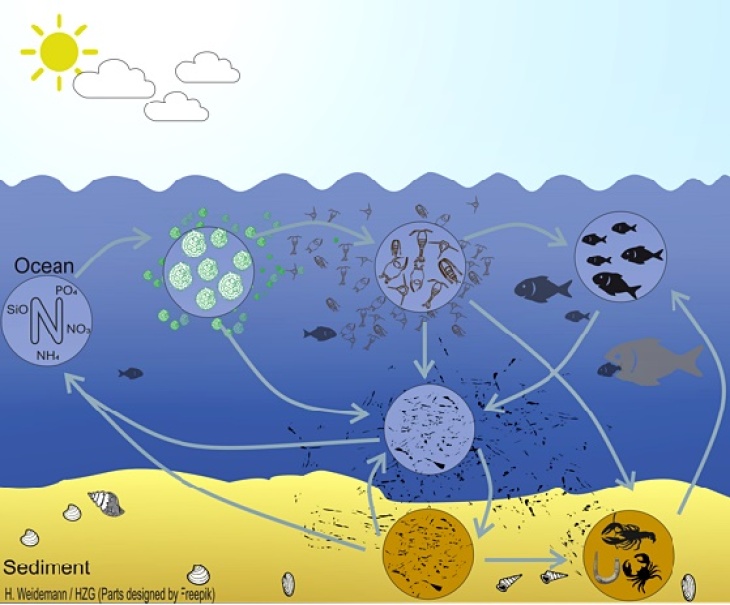
Grafic: H. Weidemann/ Hereon
To address food web related questions in the Baltic Sea, we developed the 3d coupled ecosystem model ECOSMO E2E (Daewel and Schrum, 2016), which is an NPZD-Fish modelling approach that bases on the ecosystem model ECOSMO II (Daewel and Schrum, 2013). The model represents both fish and macrobenthos as functional groups that are linked to the lower trophic levels via predator-prey relationships (Figure). The model allows investigating bottom-up impacts on primary and secondary production and cumulative fish biomass dynamics, but also bottom-up mechanisms on the lower trophic level production. mehr
Individual-based models of larval fish
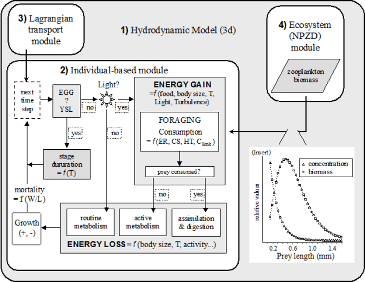
Grafic: Daewel et al. 2015 (Fig.2)
The early-life history of marine fishes is one of the main determinants of the recruitment variability and an important bottleneck in the adaptation of fish populations to changing climate and anthropogenic disturbances. Individual-based models (IBMs) that simulate the behavior of an individual fish and its interactions with the biotic and abiotic environment are widely used in fisheries science to study starvation, predation and dispersal mortality of fish early-life stages. In CoastalFutures, we are using stand-alone or coupled larval IBMs to better understand how natural and anthropogenic stressors affect mortality and survival of larval fish in the vicinity of the spawning and nursery areas of the commercially important fish species in the North and the Baltic Seas. mehr
| Infobox | |
|---|---|
| Spatial coverage: variable (depends on model setup) Spatial resolution: variable (depends on model setup) Temporal coverage: variable (depends on model setup) Temporal resolution: hourly Contact: Tahereh Nakisa, Anna Akimova, David Drewes, Ute Daewel (Thünen-Institute, Hereon) |
References
- Akimova, A., Peck, M.A., Börner, G., van Damme, C. and Moyano, M. (2023) Combining modeling with novel field observations yields new insights into wintertime food limitation of larval fish. Limnol Oceanogr. https://doi.org/10.1002/lno.12391
- Daewel, U., Schrum, C., Gupta, A. (2015): The predictive potential of early life stage individual-based models (IBMs): an example for Atlantic cod Gadus morhua in the North Sea. Mar. Ecol. Prog. Ser. 534, 199–219, https://doi.org/10.3354/meps11367
OSMOSE Model
OSMOSE is a multi-species and individual-based model (IBM) for fish species. Here, the model represents 12 species (pelagic and benthic: Sole, Haddock, Sprat, Saithe, Dab, Sandeed, Herring, Plaice, Cod, Pout, Gurnard and Whiting) of economic interest in the North Sea. The model assumes opportunistic predation based on spatial co-occurrence and size adequacy between a predator and its prey. OSMOSE represents major processes of fish life cycle (growth, reproduction, migration, and mortality). Fish individuals are grouped into schools or ‘super-individuals’ which are characterized by their size, weight, age, species, and geographical location. OSMOSE is a 2D model (horizontal representation) which have a resolution of 10km grid on the horizontal and run with a two-week’s time step. To provide prey field to the fish, OSMOSE is coupled to hydrodynamic and biogeochemical models, here NEMO-ECOSMO. In output, a variety of size-based and species-based ecological indicators are produced at different levels of aggregation: at the species level (e.g. mean size, mean size-at-age, maximum size, mean trophic level, within-species distribution of trophic level), and at the community level (e.g. slope and intercept of size spectrum, Shannon diversity index, mean trophic level of catch). https://osmose-model.org/
References
5. Species Distribution Models
5. Species Distribution Models
- 5.1 Fish distribution model (TIMoFiD)
- 5.2 Marine mammals distribution model (ITAW)
- 5.3 Distribution models of seabirds (FTZ CAU Kiel)
TIMoFiD (Thünen-Institute Model of Fish Distribution) is a species distribution model developed and applied to model the past and the future distribution of marine fishes. Although the model is generic and can be applied to various areas, we will focus here on the North and the Baltic Sea.
References
- Núñez-Riboni, I., A. Akimova and A. F. Sell, 2021. Effect of data spatial scale on the performance of fish habitat models. Fish and Fisheries, 22:955–973. DOI: 10.1111/faf.12563; Open Access: https://onlinelibrary.wiley.com/doi/10.1111/faf.12563 More information about the reference
- Núñez-Riboni, I., Taylor, M., Püts, M., Kempf A. and Mathis, M., 2019. Spatially resolved past and projected changes of the suitable thermal habitat of North Sea cod (Gadus morhua) under climate change. ICES Journal of Marine Science, Volume 76, Issue 7, Pages 2389–2403. DOI:10.1093/icesjms/fsz132. Open Access URL: https://academic.oup.com/icesjms/advance-article/doi/10.1093/icesjms/fsz132/5538730 More information about the reference
Species distribution models are often applied to estimate the effects of environmental (e.g. temperature, primary productivity, bathymetry ) or anthropogenic (e.g. intensity of maritime traffic, construction and operation of windfarms) factors on the abundance and spatial distribution of marine mammals. Once these effects are quantified, species distribution models can be used to predict distribution of marine mammals in the areas with no observations or under future conditions. In Coastal Futures, we aim to study the distribution of harbour porpoise in the North and the Baltic Seas and how this animal responds to the changing environment due to climate change and anthropogenic activities. To achieve this, data on porpoise density collected along standardized surveys together with the associated values of environmental and anthropogenic factors will be used to calibrate a species distribution model. This modelling will provide additional information to adapt future conservation and management measures for the harbour porpoise.
| Infobox | |
|---|---|
| Spatial resolution: North Sea 10 km, Baltic Sea 5 km Temporal coverage: 2002 - 2022 Temporal resolution: daily to seasonal Responsible Project Partner: ITAW Contact: Nadya Ramirez-Martinez |
References
- Gilles, A., Viquerat, S., Becker, E., Forney, K., Geelhoed, S., Haelters, J., Nabe‐Nielsen, J., Scheidat, M., Siebert, U. and Sveegaard, S. (2016). Seasonal habitat‐based density models for a marine top predator, the harbor porpoise, in a dynamic environment. Ecosphere 7 (6): e01367
- Lacey, C., Gilles, A., Börjesson, P., Herr, H., Macleod, K., Ridoux, V., Santos, M.B., Scheidat, M., Teilmann, J., Vingada, J., Viquerat, S., Øien, N., Hammond, P. (2022). Modelled density surfaces of cetaceans in European Atlantic waters in summer 2016 from the SCANS-III aerial and shipboard surveys. Final report. https://scans3.wp.st-andrews.ac.uk/resources/ More information about the reference
Knowledge on the spatial distribution of species provides valuable information on the state of marine ecosystems. Species distribution models allow to identify the environmental variables mainly influencing species occurrence, to detect when and how changes of the spatial distribution of species occur, to investigate how anthropogenic activities affect the species and to predict potential changes in the future. Developing and applying species distribution models for different seabird species, we aim to study the effects of anthropogenic activities as well as climate change which will furthermore help to evaluate conservation measures and to develop future conservation concepts.
| Infobox | |
|---|---|
| Spatial resolution: 1 km Temporal coverage: 2002 - 2022 Temporal resolution: seasonal Responsible Project Partner: FTZ CAU Kiel Contact: Stefan Garthe, Verena Peschko |
References
- Garthe S, Schwemmer H, Peschko V, Markones N, Müller S, Schwemmer P & Mercker M (2023) Large-scale effects of offshore wind farms on seabirds of high conservation concern. Scientific Reports 13: 4779, https://doi.org/10.1038/s41598-023-31601-z
- Peschko V, Schwemmer H, Mercker M, Markones N, Borkenhagen K, Garthe S (accepted) Cumulative effects of offshore wind farms on common guillemots (Uria aalge) in the southern North Sea - climate versus biodiversity? Biodiversity and conservation
6. Human Use Parametrisations
6. Human Use Parametrisations
Wind farm parameterization in regional climate model COSMO-CLM
This module of wind farm parameterization in the regional climate model COSMO-CLM1 allows the simulation of wind farms on a large spatial and temporal scales. The use of this module in COSMO-CLM allows to study the impact of wind farms on regional climate, air-sea fluxes, and power generation2,3.
| Infobox | |
|---|---|
| Spatial resolution: up to 2 km Temporal coverage: depends on scenario Temporal resolution: 1 hour Responsible project partner: Hereon Contact: Naveed Akhtar |
- 1. Akhtar, Naveed; Chatterjee, Fabien (2020). Wind farm parametrization in COSMO5.0_clm15. World Data Center for Climate (WDCC) at DKRZ. https://doi.org/10.35089/WDCC/WindFarmPCOSMO5.0clm15
- 2. Akhtar, N., Geyer, B., Rockel, B. et al. Accelerating deployment of offshore wind energy alter wind climate and reduce future power generation potentials. Sci Rep 11, 11826 (2021). https://doi.org/10.1038/s41598-021-91283-3
- 3. Akhtar, N., Geyer, B. & Schrum, C. Impacts of accelerating deployment of offshore windfarms on near-surface climate. Sci Rep 12, 18307 (2022). https://doi.org/10.1038/s41598-022-22868-9
- 4. Christiansen N, Carpenter JR, Daewel U, Suzuki N and Schrum C (2023). The large scale impact of anthropogenic mixing by offshore wind turbine foundations in the shallow North Sea Front . Mar. Sci . 10:1178330. https://doi.org/10.3389/fmars.2023.1178330
Sponsors